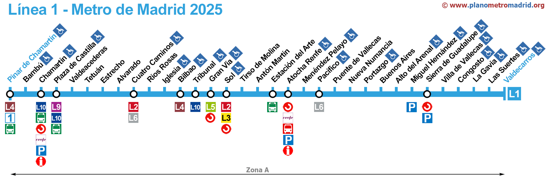
Map of the line 1 of the Metro Madrid
Updated: January 2025
Welcome to our web of the map of line 1 of the Madrid metro (L1).
Madrid Metro Line 1.
On the map below are all stations of line 1, updated in January 2025.
If you wish, you can also see a page of the complete metro map of Madrid, showing all the metro lines together or you can see other lines one by one:
Line 1 | Line 2 | Line 3 | Line 4 | Line 5 | Line 6 (Circular) | Line 7 | Line 8 | Line 9 | Line 10 | Line 11 | Line 12 (Metrosur) | Line R (Ramal) | Map
Station of Metro Line 1 (L1)
Pinar de Chamartín - Valdecarros
Line 1 of the Madrid Metro has 33 stops. Each station listing includes whether you can transfer to other forms of public transportation, like other metro lines, train stations, or bus stops. It also notes if the stations are wheelchair accessible or equipped for prams. By clicking on a station's name, you'll be directed to the official website for more detailed information about that metro station.
| STATION | ZONE | INFO |
|---|---|---|
| Pinar de Chamartín | A |    Intercity buses Intercity buses |
| Bambú | A | |
| Chamartín | A |   RENFE (train station) Intercity buses RENFE (train station) Intercity buses  Train Station long distance RENFE Train Station long distance RENFE |
| Plaza de Castilla | A |  Intercity buses Intercity buses |
| Valdeacederas | A | |
| Tetuán | A | |
| Estrecho | A | |
| Alvarado | A | |
| Cuatro Caminos | A |   |
| Ríos Rosas | A | |
| Iglesia | A | |
| Bilbao | A | |
| Tribunal | A | |
| Gran Vía | A |  |
| Sol | A |  RENFE (train station) RENFE (train station) |
| Tirso de Molina | A | |
| Antón Martín | A | |
| Estación del Arte (AKA Atocha) | A | Intercity buses |
| Atocha Renfe | A | RENFE (train station) Train Station long distance RENFE  Buses to the airport Buses to the airport |
| Menéndez Pelayo | A | |
| Pacífico | A | |
| Puente de Vallecas | A | |
| Nueva Numancia | A | |
| Portazgo | A | |
| Buenos Aires | A | |
| Alto del Arenal | A | |
| Miguel Hernández | A | |
| Sierra de Guadalupe | A | RENFE (train station) |
| Villa de Vallecas | A | |
| Congosto | A | |
| La Gavia | A | |
| Las Suertes | A | |
| Valdecarros | A |
If you find a bug or have a suggestion, please contact us.
Thank you for visiting, we hope that our map of the subway line 1 of Madrid has been helpful to you.