Madrid Metro Map
Updated: May 2024
Here's the Madrid metro map and other information that may be useful for travelling through the underground tube network of Madrid.
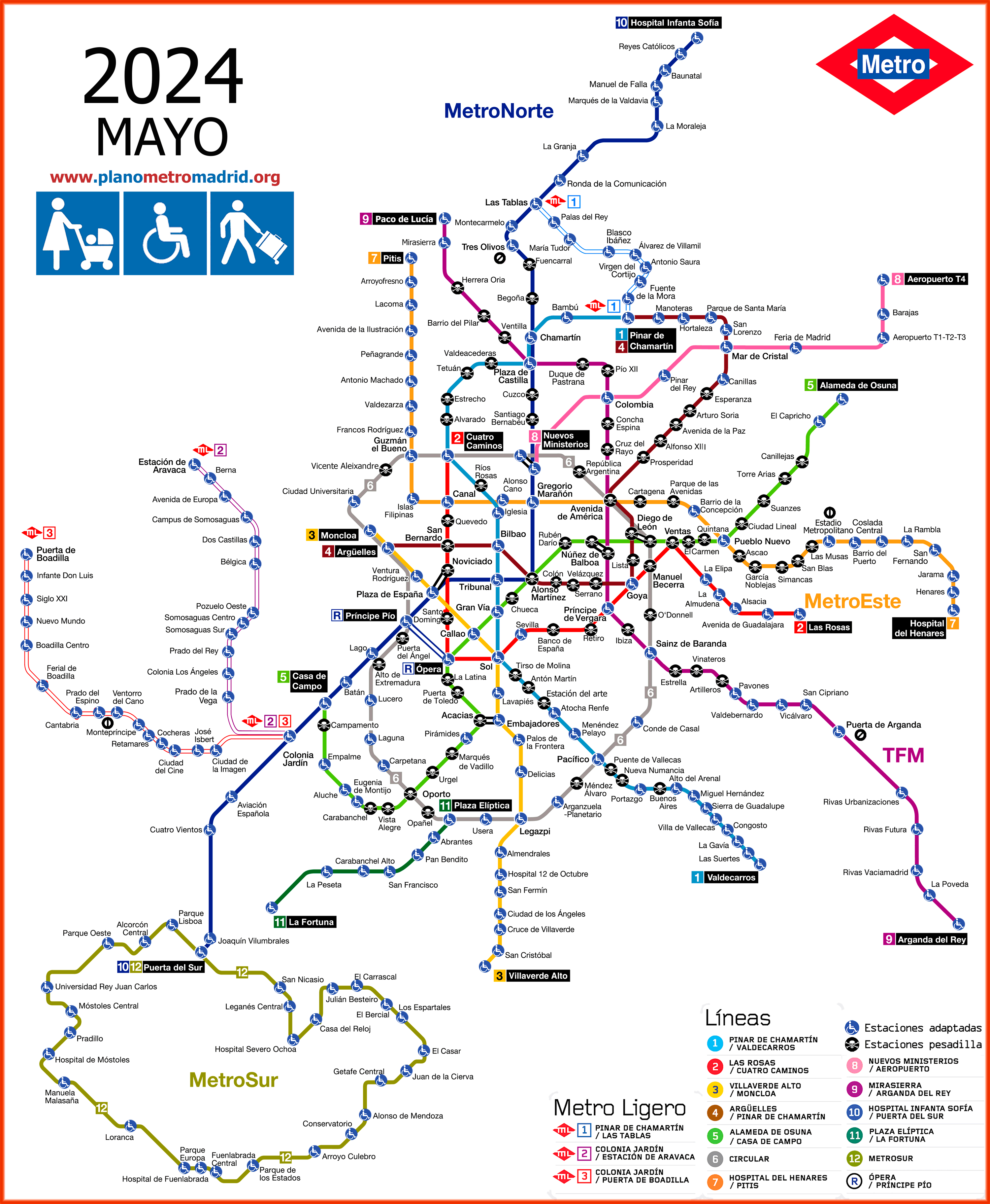
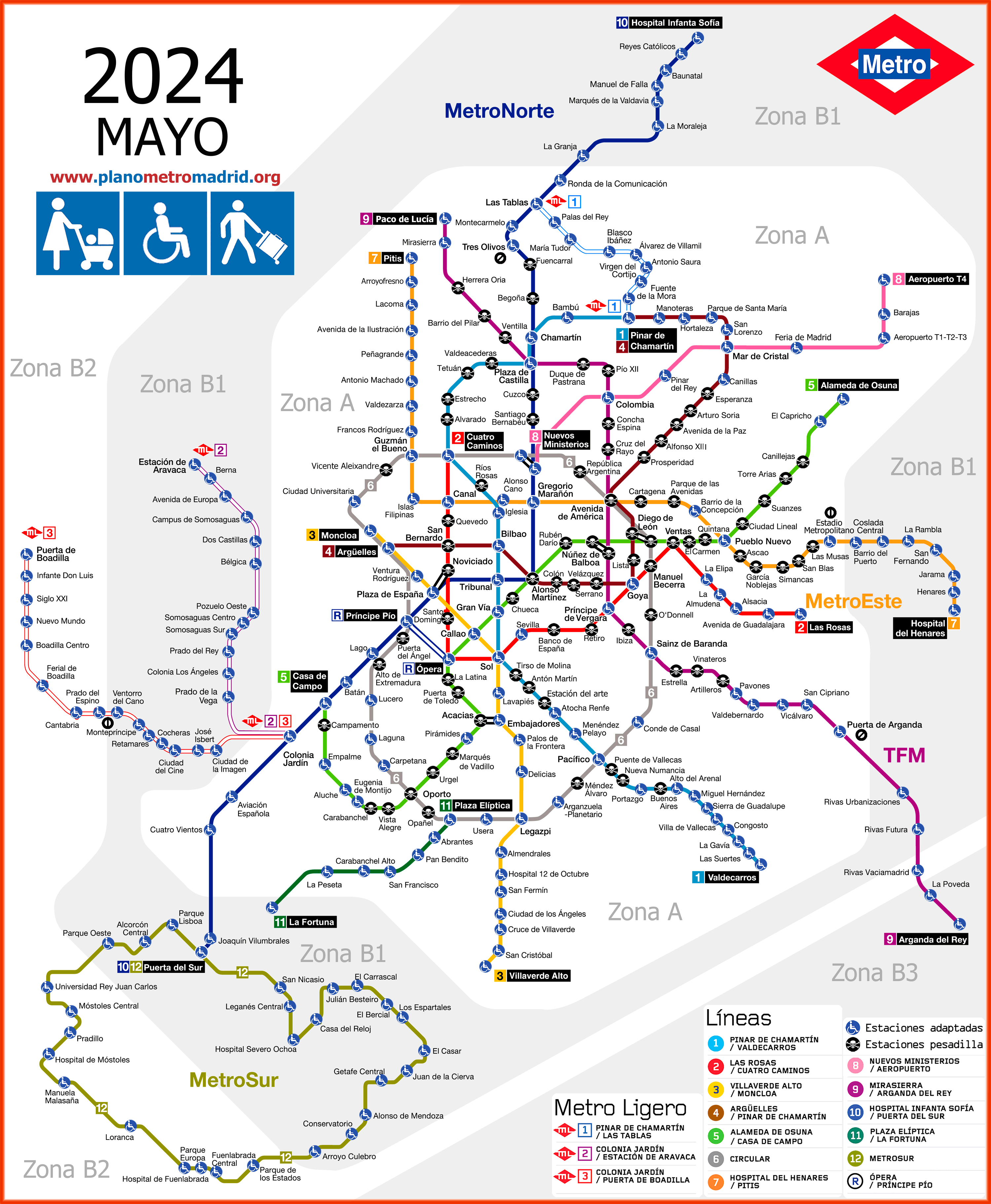
There are six versions of the map, geographic, schematic, and the same but adapted for disabled individuals, people with prams, or those with luggage.
We also have a PDF version of all the maps, should you need it.
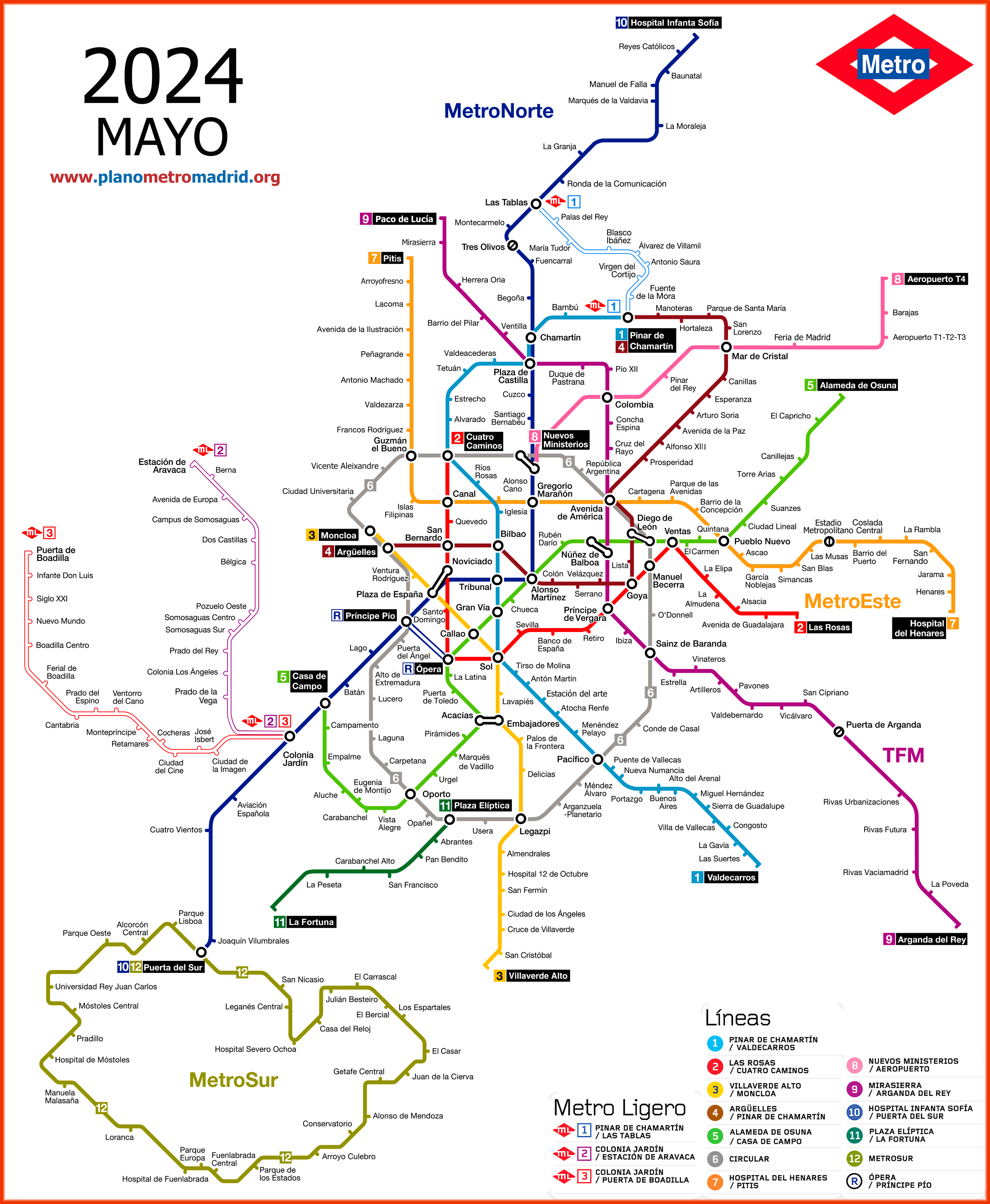
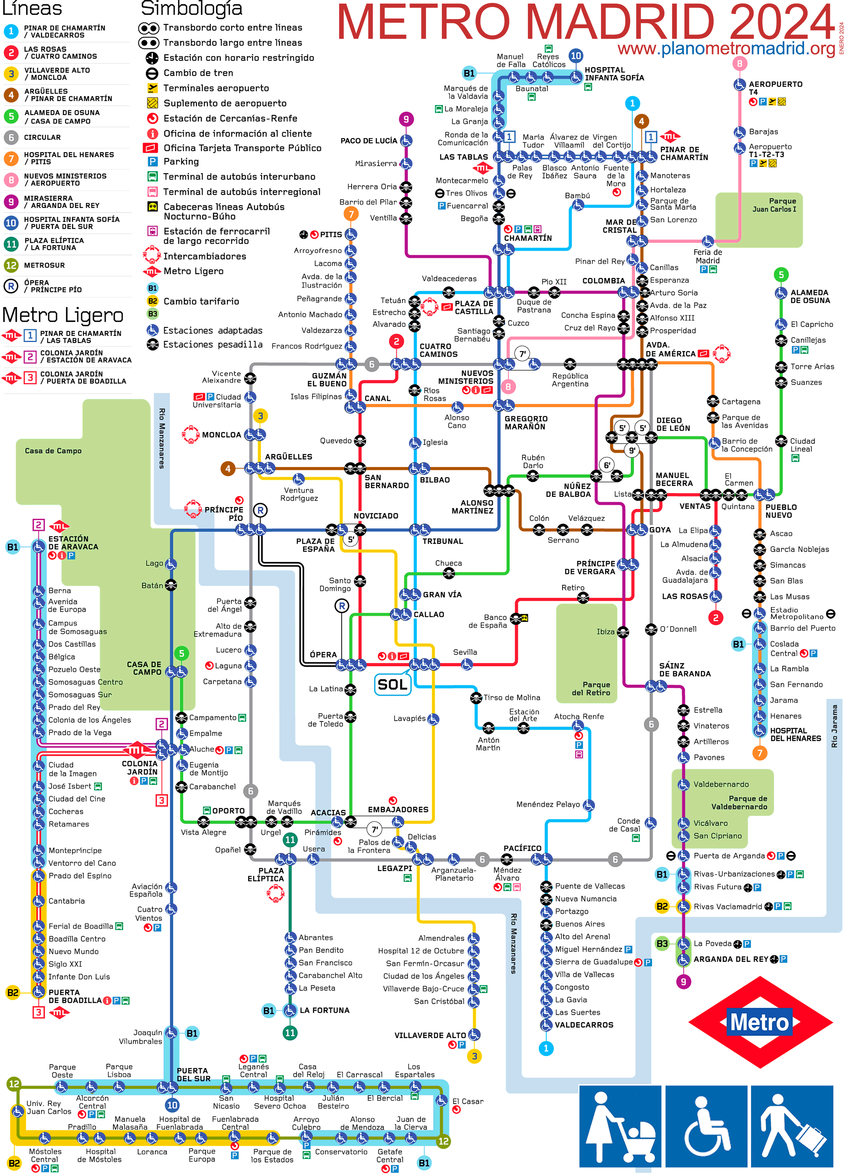
MADRID METRO MAP |
ACCESSIBILITY MAP Stations marked as "pesadilla" (nightmare) mean that for people with babies, with reduced mobility, or tourists with luggage, these stations are problematic. |
NORMAL AND WITH ZONES |
ACCESSIBLE AND WITH ZONES |

UNDERGROUND MAP |
ACCESSIBLE UNDERGROUND SCHEMATIC MAP 2024 |
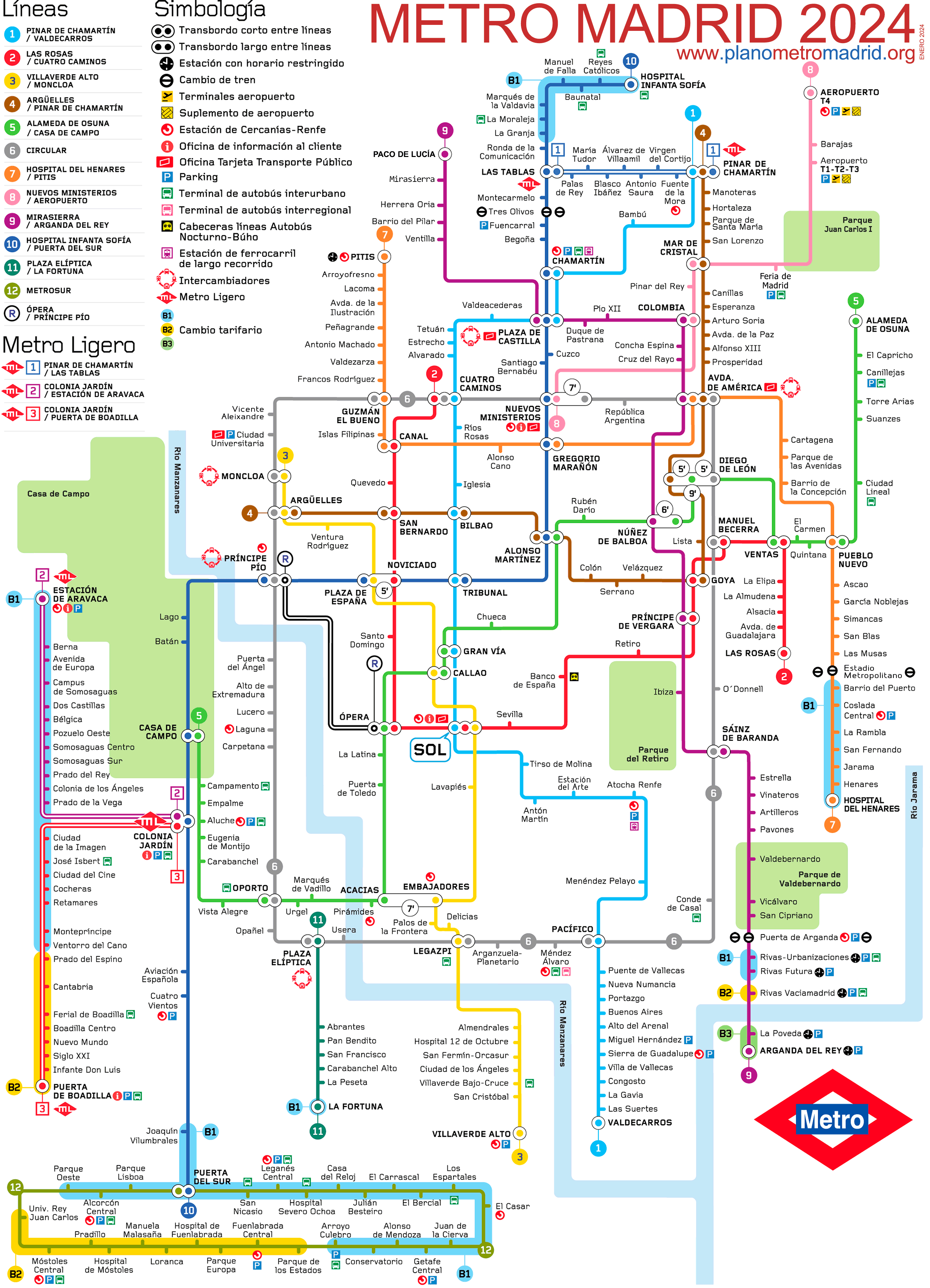
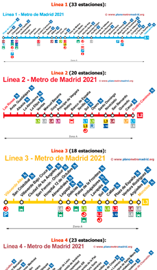
Madrid Metro Map by Lines If you wish to view a specific line, here are the maps of Madrid Metro lines individually, that is, one by one: Line 1 | Line 2 | Line 3 | Line 4 | Line 5 (green) | Line 6 (Circular) | Line 7 | Line 8 | Line 9 | Line 10 | Line 11 | Line 12 (Metrosur) | Line R (Branch)
|
Where to Buy Tourist Tickets Online?RECOMMENDATION for Visitors: Just like in other capitals, here in Madrid you will also find "packages" designed to make your visit easier and save money. Some attractions require buying tickets online to control the flow of visitors, and in places like the Royal Palace or Warner Park where queues to buy tickets can be long: - Madrid Pass: Priced at 89.00€, it includes access to the Prado Museum, the Royal Palace, the tourist bus, and more. There are often long queues to buy tickets under blazing sun or intense cold, but with this pass, everything is easier. - Variety of "packages": If the Madrid Pass doesn't meet your needs, you'll find a wide range of "ticket packages" that may better suit what you're looking for. There are family, cultural, historical packages, and more. The more people, the more you save. - And even if you don't buy anything, we suggest you explore Tiqets to get ideas of things to do in Madrid. This website has the widest range of tickets of all kinds. Even if you live in Madrid, you'll discover both monuments and attractions you might not have considered, available both day and night. You'll also find the most sought-after, like tickets for the tourist bus, Thyssen-Bornemisza National Museum, Reina Sofía Museum, Bernabéu Stadium Museum... Plus, you can save up to 20% on some tickets, as we don't know how, but almost everything they offer is cheaper than buying tickets in person. |
As can be seen in the Madrid metro map, there are 12 lines, 287 stations. The total length of all lines and stations combined, is about 293 Km. Not bad for being one of the oldest metro systems in Europe.
The Madrid metro map has been redesigned several times over the years and new metro lines and tram (light rail) lines have been added. Because the metro system is so extensive, it was necessary to create a schematic map, the drawback being that the position of the stations and the distances between them do not correspond with their geographical locations in Madrid.
To correct this problem, the Madrid Metro Authority had no choice but to make the metro map similar to the old one. Although it is not as flashy in terms of graphics, it is much closer to the geographic reality.
If you find any problems or incorrect information, please use our contact form so we can fix the problem ASAP (as soon as possible).
- GERMAN: Madrid U-Bahn Plan (Underground Madrid Karte), map schematic 2024.
- ARABIAN: map schematic 2024 خريطة مترو مدريد
- CHINESE: 马德里地图地铁 map schematic 2024 - 馬德里地圖地鐵 map schematic 2024年
- JAPANESE: マドリードの地下鉄路線図 map schematic 2024
- KOREAN: 마드리드지하철 노선도 map schematic 2024
Madrid metro map | Timetable | Ticket prices | All subway lines | Tourist map